


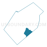
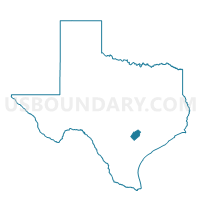
Voting District 0014, Gonzales County, Texas
About
Outline

Summary
| Unique Area Identifier | 673402 |
| Name | Voting District 0014 |
| County | Gonzales County |
| State | Texas |
| Area (square miles) | 46.18 |
| Land Area (square miles) | 46.13 |
| Water Area (square miles) | 0.05 |
| % of Land Area | 99.88 |
| % of Water Area | 0.12 |
| Latitude of the Internal Point | 29.30887300 |
| Longtitude of the Internal Point | -97.42792700 |
Maps

Graphs
Select a template below for downloading or customizing gragh for Voting District 0014, Gonzales County, Texas


Neighbors
Neighoring Voting District (by Name) Neighboring Voting District on the Map
- Voting District 0001, Gonzales County, TX
- Voting District 0010, Gonzales County, TX
- Voting District 0015, Gonzales County, TX
- Voting District 0018, DeWitt County, TX
- Voting District 0026, DeWitt County, TX
Top 10 Neighboring County Subdivision (by Population) Neighboring County Subdivision on the Map
- Westhoff-Arneckville CCD, DeWitt County, TX (2,138)
- Cost-Wrightsboro CCD, Gonzales County, TX (1,446)
- Smiley CCD, Gonzales County, TX (1,069)
Top 10 Neighboring Unified School District (by Population) Neighboring Unified School District on the Map
- Gonzales Independent School District, TX (13,026)
- Cuero Independent School District, TX (10,492)
- Nixon-Smiley Consolidated Independent School District, TX (4,957)
- Westhoff Independent School District, TX (483)